I spent a bit of time after work on Friday to google map the layout of the branch rail line that winds it's way through the industrial area of Scarborough just south of Eglinton, ultimately crosses Comstock where it ends beside Griffith Laboratories.
It was plenty warm and sunny out. It's about 3 miles for me to get to Comstock before I pick up the rails. So at 10 this morning I moseyed out the door, Sony and smartphone in hand.
It took 35 minutes to reach the line. I'm not sure if this section is technically part of GECO, but others have referred to it as such. The shine on the rails away from the road show that it receives sporadic but frequent use. Some dry goods hoppers were parked at the very end of the line. Crossing Comstock the line makes a bend eastward and parallel to Comstock.
I head south on Faulkland and east on Leahurst, passing through a gate to Hymus. A short section nearly unmarked crosses Faulkland.
The branch then crosses Hymus with a sign 'watch for flagman' at the south rail entrance. South and east the railline looks abandoned, except for the sheen on the surface.
Just after this it crosses Warden Avenue with dediated lights and a control box on the east side. I failed to get a pic of the box and mile marking, though. I'll have to fill this in sometime later.
The next section is hard to get access to. I had headed south and crossed a dead end street (Upjohn) instead of sticking to Hymus which may have granted one or two viewing points. The end of Upjohn was blocked by fencing for a material business. However, from my viewpoint I caught this image of what appeared to be a subway car, numbered 5707, sitting probably on the line. Google shows no second tracks in the area. I found that interesting.
Edit: The car turns out to be TTC car H5 5707, a Hawker-Siddeley unit. Unknown why it as this location.
With no route to the north, I head south and cross the housing development that used to be Warden Woods Mall. At the N/E corner is a pathway that passes just south of a short N/S extension which branches from the segment followed so far to the west, and east towards the Uxbridge sub. This extension is necessary as the lines E/W do not directly meet.
At this point I was past 45 minutes into the run. Breeze was good and outside of some sweat I was fine, courtesy of a number of lunchtime runs at high noon in 90+ degree temps that this feel easy by comparison. I still wanted to follow the line through so onwards to the crossing at Birchmount. Another significant road level crossing marked as mile 2.12 on the CN signal control box.
A gravel parking area inhabited by a cabless tractor trailer gave a chance to shoot some close images of the rail bed area.
Extensions on the ties reveal that this was a small yard at one point with at least two additional spurs. Stacks of rails and ties lay by the tracks.
The east side starts making a slow southward turn. A gravel path follows the south side with hydrolines overhead. The track actually divides into two lines at this point. The track continues eastward with banks on the northside over which the hydrolines pass.
Eventually it exits at a familiar crossing on Kennedy Road just south of Eglinton.
The signal box at Kennedy is marked as GECO mile 2.79.
Stops signs for the trains (not the traffic) are located on each side of the roadway.
The track then tucks into a tight restricted area and begins an aggressive bend southward. The TTC Kennedy parking lot sits just north of the line. At the south-east corner the rail can be seen passing by the backyards of trackside homes.
Adjacent to the TTC station sits the Kennedy GO station. Standing just off the platform and looking a couple of hundred yards down the track, you can spot the section where the GECO branch veers away from the Uxbridge Subdivision that runs GO trains north to the Stoufville area.
North of Eglinton, the Uxbridge line parallels the LRT rails to Scarborough Town Centre. Note that the northbound signal on the Uxbridge line is red. The schedule marked at the GO station only showed times for Mon-Fri, although I may have read it wrong. I was hoping maybe I'd at least catch a GO train in motion along Uxbridge as there would be nothing moving on GECO on this day.
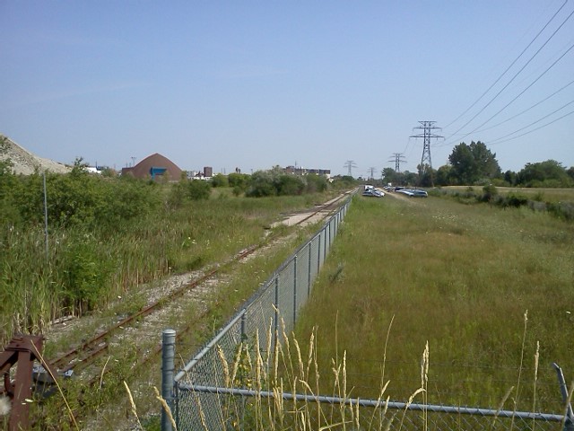
I was now an hour 15 into my run. It would take about 45-50 minutes to return more directly. I snapped one final shot of GECO just east of Kennedy with a view alongside the hydro lines over to Birchmount.
As I headed south on Kennedy to return home, I took a quick glance upon reaching St. Clair to see if, by chance, anything may be moving on the Uxbridge Sub. Sure enough, the engine and lead car of a GO unit were very slowly making their way southbound. This would be the reason the north signal was red on the line back at Eglinton. Just my luck, I would have caught it coming over the light rise at occurs at the far end of the track had I waited another 10 minutes or so. At St. Clair I was too far to snap the train with my cell phone camera, and couldn't cross the street in time to catch it with the Sony.
So no moving action, except some video of the LRTs in motion. It was fun tracking the GECO branch, though. With a little luck, one could catch CN moving those dry tankers out of Griffith labs during the week. With the intimacy of the branch and the roadways, that would be some pretty action to shoot.
I made it back to my local park just under 2 hours, hopped in a park washroom and chugged handfuls of nice cold water as I was pretty dry by that point, then finished the run through the park back home. The last mile was a bit sluggish but capped off a good 2ish hour run and some rail fun.
Edit: I passed this way again on the weekend. Curious of the subway car by the aggregate dome, I viewed it from the other side:
The car sits on the asphalt, maybe used as an office or storage area. Go to youtube and you can find some vids with this car, TTC #5707.